Laveno-Mombello
| Laveno-Mombello | |||
|---|---|---|---|
| — Comune — | |||
| Comune di Laveno-Mombello | |||
| Laveno | |||
|
|||
|
Laveno-Mombello
|
|||
| Coordinates: | |||
| Country | Italy | ||
| Region | Lombardy | ||
| Province | Province of Varese (VA) | ||
| Area | |||
| • Total | 25.9 km2 (10 sq mi) | ||
| Population (Dec. 2004) | |||
| • Total | 8,991 | ||
| • Density | 347.1/km2 (899.1/sq mi) | ||
| Demonym | Lavenesi, mombellesi | ||
| Time zone | CET (UTC+1) | ||
| • Summer (DST) | CEST (UTC+2) | ||
| Postal code | 21014 | ||
| Dialing code | 0332 | ||
Laveno-Mombello is a comune (municipality) in the Province of Varese in the Italian region Lombardy, located about 60 km northwest of Milan and about 20 km northwest of Varese. As of 31 December 2004, it had a population of 8,991 and an area of 25.9 km².[1]
The municipality was formed in 1927 to encompass the previously separate centres of Laveno, Mombello and Cerro.
The name of Laveno comes from the Latin word "labes", that means "landslide". It is common thought that the name comes from the Roman general Titus Labienus, but actually just the main road of the town, via Labiena, is named after him. Titus Labienus is considered responsible for naming Mombello too, after a battle against the Gauls ("mons belli" means "war hill"). A different interpretation says that the meaning is "monte bello", that is "beautiful hill".
In the 19th Century, Laveno Mombello was home to important ceramic industries. Today, it is a port town that connects the province of Varese with Verbania and the famous Borromean Islands across Lake Maggiore.
Laveno-Mombello borders the following municipalities: Caravate, Castelveccana, Cittiglio, Ghiffa, Leggiuno, Sangiano. Stresa and Verbania are in front of the town across the lake.
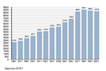
Demographic evolution

External links
References
|
||||||||||||||||||||||||||